Home
About
Us
Projects
Clients
Email Us
31 School Street
Hyannis, MA 02601 USA
Phone: 508-827-4169
Cell: 508-221-8620
Fax: 508-957-2191
Email Us
Deep Water Ocean Current Measurements at multiple locations Makassar Strait and Sulawesi Sea, Indonesia
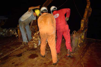
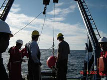
April 2001 to presentTo augment regional coverage, Unocal requested two (2) additional current meter systems be purchased and deployed at selected locations (confidential) in the Sulawesi Sea and Makassar Strait. Ocean Data designed and installed additional current meter systems over the course of the next several years. Each location was instrumented consecutively, that is, moved from location to location with little intermediate downtime. Field operations were combined with other Unocal-sponsored current measurements in the region. The following table represents the location, water depth, duration of the deployment, and number of service operations. Data return rates for these programs exceeded 99.9%. At this time, Ocean Data personnel were servicing multiple mooring systems during each trip to the region, with trips occurring about every 3-4 months, or more frequently upon special request. The field team consisted of two (2) Ocean Data personnel. In all cases, Ocean Data personnel were responsible for all field operations, logistics, and data management. In what became a routine matter, Ocean Data would initiate email contact with Unocal vessel logistics coordinators, those individuals responsible for rig moves, anchor handling, and supply runs. Based on rig and vessel activities, Ocean Data would utilize available chartered boats to perform the mooring servicing, minimizing delays and cost. Ocean Data designed the servicing operations to be compatible with nearly any available vessel; and demonstrated the proficiency of our methods with a zero-incident safety record (since program inception in 1999).
Location/Name Waterdepth(m) Start Date End Date Duration (days) Data Recovery Location I 1407 8-Apr-2001 4-Dec-2001 240 100% Location II 1688 6-Dec-2001 16-Mar-2002 100 100% Location III 1108 17-Mar-2002 25-Jun-2002 100 100% Location IV 872 30-Jun-2002 28-Jun-2003 363 100% Location V 1944 29-Jun-2002 13-Dec-2002 167 100% Location VI 1931 18-Jan-2003 26-Feb-2004 403 100% Location VII 2054 30-Jun-2003 04-Dec-2004 523 96% Location VIII 1594 18-Nov-2003 27-July-2004 251 100% Location IX 1000 28-Feb-2004 03-Dec-2004 279 100%
These mooring systems continue to collect current information presently at additional locations in the Makassar Strait. Ocean Data services these systems and reports results on a periodic basis.